Data, not fear

One of the biggest challenges of ultralight backpacking is rational thinking: properly assessing probabilities associated with the various possibilities. There are all sorts of things that could happen. But what's most likely to happen? How can you Be Prepared, but not pack your fears? While that question and the associated challenges apply to all manner of considerations, one of the most common faced is weather.
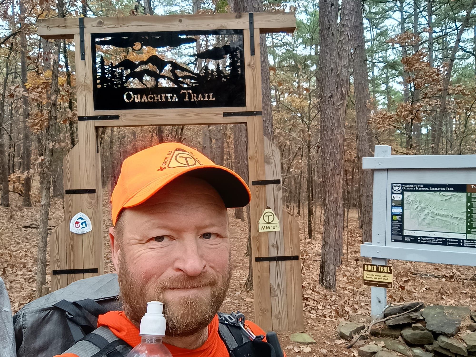
For the weather question, I will illustrate my strategy/methodology by reviewing how I planned for the Ouachita Trail trip, November 26 - December 10 2024. The Ouachita Trail runs from Talimena State Park Oklahoma to Pinnacle Mountain State Park, Arkansas.
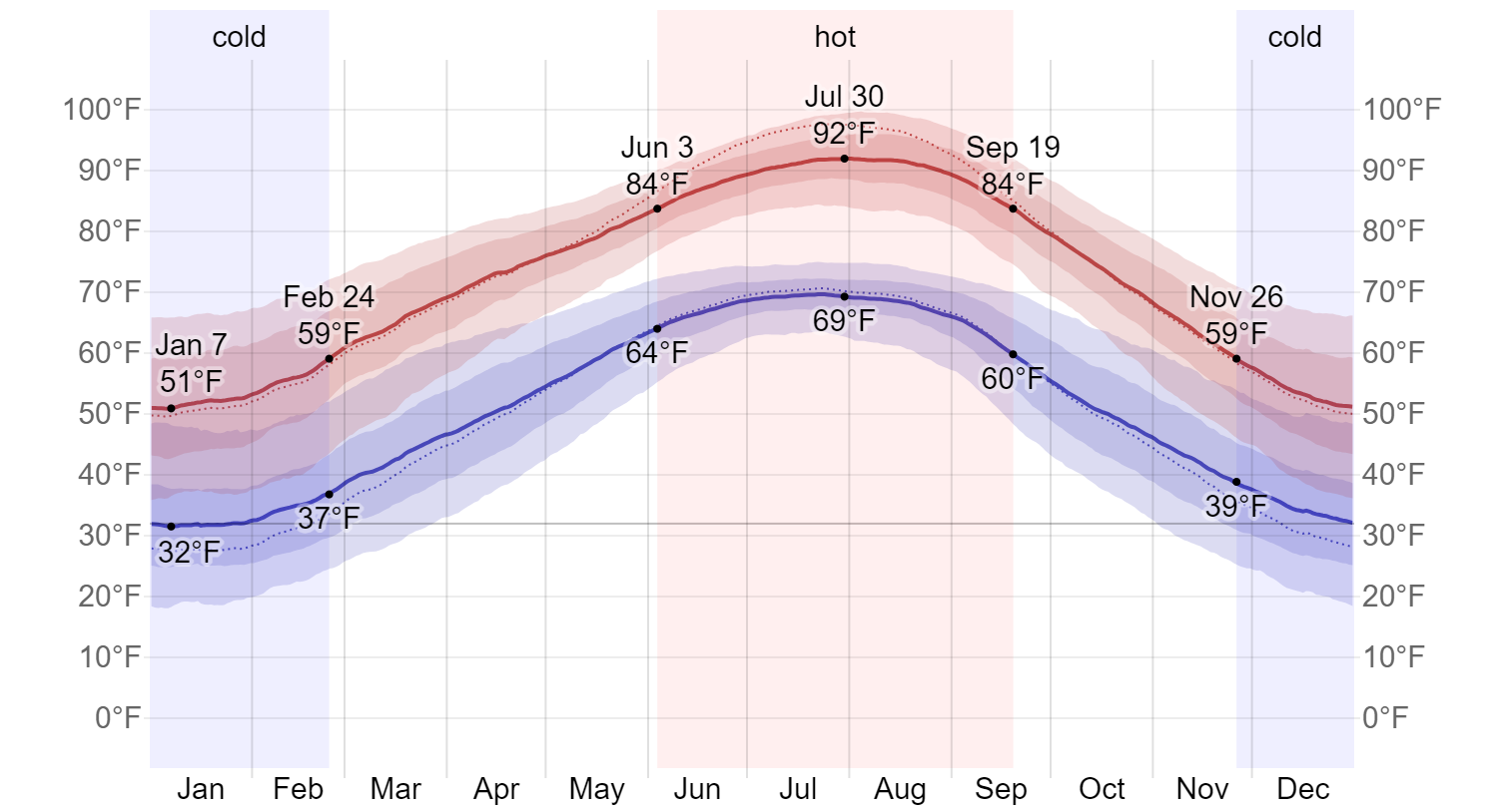
I started my planning by going to Weatherspark.com and navigating to the weather station closest to the midpoint of the Ouachita Trail (Mount Ida), to obtain this chart:
Clicking on hyperlinked "Nov" at the bottom of that chart yields:
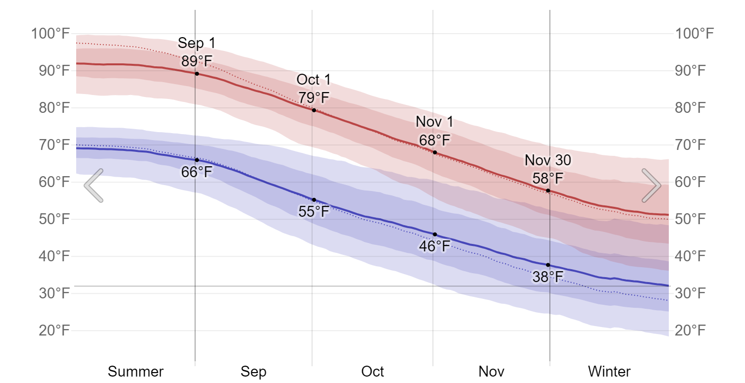
Clicking on the hyperlinked dates within the chart will drill down even further to values for that particular day.
The average high is the red line. The average low is the blue line. The darker pink region represents the 25th-75th percentile range temperatures. The lighter pink region represents the 10th-90th percentile range. Likewise the darker blue region represents the 25th-75th percentile temperatures, and the lighter blue region represents the 10-90th percentile.
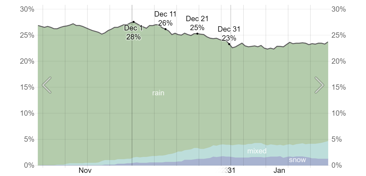
In other words, 90% of the time the overnight low on December 1 is going to be 25 degrees or warmer in Mount Ida. One could expect that the 10th percentile low would/could be a few degrees lower in the mountains (see altitude adjustment below.) 90% of the time the daily high is going to be 68 degrees or lower.
Other critical weather data available at weatherspark includes charts showing cloud cover, humidity, average wind speed, probability of precipitation (broken out by type of precipitation - i.e. rain vs. snow vs. mixed), and average monthly precipitation amounts.
Altitude Adjustment
But what if the closet weather station is at a much lower elevation than where you plan on sleeping? Like, for instance, if you wanted to hike the Teton Crest Trail in Grand Teton National Park, where you'll be anywhere from 7,000 - 11,000 feet, when the closest weather station is in Jackson, Wyoming (Elevation 6200 feet)? All other things being equal, the temperature goes down 3.5 degrees F for every 1000 feet of elevation gain. So, if the 10th percentile low at Jackson is 30 degrees, and you'll be staying at 8800 feet, you can anticipate that the same 10th percentile low would be (8800-6200)/1000*3.5 = 9.1 degrees lower, or 20.9 degrees. And if you were staying at 10,000 feet that would be (10,000-6,200)/1000*3.5= 13.3 degrees lower, or 16.7 degrees. The day time highs would likewise be lower by the same amount. Keep in mind that this is the temperature difference purely due to altitude. There are other factors (like storms) that can impact this as well, but that is short term weather rather than long term climate/trends, which is what you want to use for planning purposes.
How I used this for the Ouachita Trail trip
With respect to rain, I expected I would face some sort of precipitation on 1 out of 4 days, or 25% of the time. As it turned out, I had rain on 2 of 10 days. But I got lucky. I did not face heavy rain while I was walking. The only heavy rain occurred while I was in a shelter. (I monitored the weather daily and did what I could to ensure that would be the case.) But my trip plan included provision for getting wet while walking. And I had to consider that the temperatures might have simultaneously been cold. (The worst case, of course, would be freezing rain.) To account for those conditions, I brought an Alpha Direct hoodie and set of Alpha Direct pants specifically to change into should those conditions occur. Thankfully, they did not.
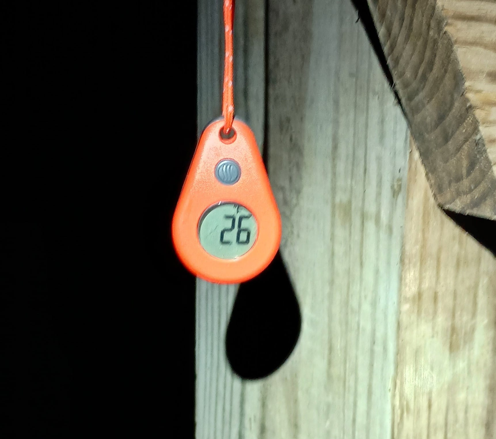
I planned for an overnight low down to 20 degrees. For this I brought my 20 degree Conti quilt by Timmermade, paired with my Thermarest Xtherm. I also brought the Timmermade alpha/argon overquilt to mitigate condensation issues/concerns. I wore base layers to bed each night to keep the interior of the quilt clean. Several nights were in the high 30s, and one was 42. I was overly warm/sweating and had to ventilate on those nights. But I was very comfortable on the 26 degree night at Fiddler Creek shelter.
In retrospect I very likely would have been comfortable at 26 in my 30 degree Cedar Ridge/down bootie combo paired with the Alpha/Argon overquilt. Such a setup would have saved me 110 grams of weight. What would I have done on the 10% chance the low was below 25 degrees? I would put on my puffy (and/or other clothes.) My puffy, the Alpha Direct layer, spare socks, and other gear spent each night of the trip in a MYOG/UL stuffsack as my pillow. If the worst had happened, I would simply have not had nearly as comfortable of a pillow.
Hike on my friends.